

Design And Engineering Strategies for Changing Water Levels
Published on July 1, 2026


If there is anything constant in the world of marinas, it would be the fact that water levels always seem to be changing. Of course, there always seems to be too much water, causing facilities to flood, or there isn’t enough water due to drought, forcing marinas to plan for dredging to keep boaters in the water.
Very few marinas are located in the Goldilocks zone, where water levels remain reasonably predictable and consistent within a foot or two, and these are most often found on water level-controlled reservoirs. When planning for water levels at marinas, it is important to consider the following environmental, operational and code issues (depending on location).
Tidal Range: For all coastal locations, it is critical to document both normal tidal ranges and highest and lowest recorded tide elevations. Note that these are “normal events” that primarily affect the design of the docks and gangways, rather than peak flood events during storm surges that affect upland structures and utility infrastructure.
Sea Level Rise (SLR): Sea Level Rise is the ongoing long-term increase in ocean water levels caused by several factors related to warming temperatures. First, as the temperature of the oceans rise, the water itself expands and occupies a greater volume of space, and second, melting ice caps increase the total volume of water in the ocean. Whatever your feelings may be on the causes of climate change, the fact is that it is happening. The only questions are how high the water levels will rise at a particular location and how soon. Every location will be affected differently based on local conditions, but according to the National Oceanic and Atmospheric Administration (NOAA), Florida is expected to see water levels in 2050 approximately 10 to 18 inches higher than water levels in the year 2000. For those building or renovating a marina today that is expected to have a design life of 30 to 50 years, assume the water levels will be at least one foot higher than they are right now in design calculations.
Great Lakes Long-Term Water Levels: While the Great Lakes are generally not subject to Sea Level Rise issues, they do all experience both annual and long-term water level fluctuations. Lake Michigan, for example, experiences 12 to18 inches in water level change during a normal year, and a long-term range of approximately 6 feet between record highs and lows, generally over a period of five to 15 years. The best data from NOAA suggests that the lake levels will remain reasonably close to these historic ranges, but the pace of change from high to low is expected to be much more volatile in the future.
Storm Surge Conditions: For both Great Lakes and coastal sites, the short-term impacts of storm surge and wind setup, which temporarily increases the water levels over longer term static water levels, need to be considered. On Lake Michigan, water levels can increase simply from sustained winds up to nearly 2 feet for periods of a day or two. On coastal sites, particularly in hurricane prone areas, water levels can increase by 10 feet or more.
Seasonal Flooding: For riverine environments, spring flooding from snow melt or heavy rains must be accommodated. Marinas need to keep in mind the relationship of peak flood elevation to the height of the guide piles on floating docks and ensure that, even at record flood elevations, the docks will not float over top of the guide piles and subsequently float away.
Reservoir Issues: Reservoirs are much less likely to encounter flood events above a predicted level, which makes upland planning easier. On the other hand, long-term droughts can reduce water levels to the point where floating dock systems must be moved to “chase” the water, or at some point the marina simply can no longer operate. Keep in mind also the potential effects of a large maintenance project on the dam that maintains the water levels. It is not unheard of for reservoir water levels to be lowered for extended periods to allow maintenance projects to proceed, potentially shutting down marinas on that reservoir.
Base Flood Elevation Regulations: Base Flood Elevations are more akin to zoning requirements, where jurisdictions establish a minimum base elevation below which buildings cannot be constructed. In southern Texas, that elevation could be +9, whereas other locations may be 4 to 8 feet above sea level.
Americans with Disabilities Act (ADA): ADA requirements for recreational boating facilities cover everything from accessibility in upland structures to providing accessible routes and gangways from parking areas to boat slips. The key factor for marina design related to water levels is gangway slope connecting upland areas to floating docks. ADA requires a maximum slope of 1:12 (8.33%) at low water, up to a gangway length of 80 feet. If a marina provides an 80-foot gangway, then it could theoretically be any slope and still be compliant. An absolute maximum slope of 1:6.5 (15%) for basic safety and usability is recommended, which corresponds with the typical maximum slope of a boat launch ramp (also compliant with ADA requirements).
Electrical Datum Plane: The Electrical Datum Plane is most affected by water levels on fixed dock structures. Codes now require that all electrical connections within marinas must be made above the electrical datum plane, which is at least two feet above “highest normal water” or highest measured tide on fixed dock structures. On floating structures, the electrical datum plane is 30 inches above the water level and at least 12 inches
above the surface of the deck.
Ordinary High Water Mark (OHWM): OHWM is a concept used to define the precise location where permitting efforts are considered “upland” (above OHWM), or “marine” (below OHWM). OHWM is established both by the U.S. Army Corps of Engineers (Corps) and the relevant state regulatory agency, and they do not always agree. For example, on Lake Michigan, the Corps has established OHWM as elevation 581.5, while the state of Michigan has established OHWM as elevation 580.5. In some states, such as Wisconsin, OHWM is determined by on-site delineation (similar to wetlands) rather than a set water level elevation.
So, how do marina owners apply all of these various factors at their facility? First, collect all available data for the site, beginning with topographic and bathymetric surveys. This will allow owners to determine the precise location of OHWM and the base flood elevation, which drive all other design requirements. From there, overlay daily, annual and long-term water level fluctuations (tidal, seasonal and long term/SLR) to establish the new base elevation for upland seawalls, buildings and waterside promenades that need to stay dry. The relationship between this upland elevation and the water level will allow owners to determine if fixed docks are even a potential practical solution, or if floating docks should be the preferred solution. When considering floating docks, the main issue will be maintaining ADA compliant gangway access as noted above.
It is important to make a distinction between what absolutely must always stay dry (most buildings and electrical infrastructure), and what can occasionally get wet for short periods of time. This distinction is critical in the function of the facility and can greatly impact costs. A marina does not want the fixed docks and boardwalks 8 feet above the water.
Michigan Maritime Museum, Lake Michigan
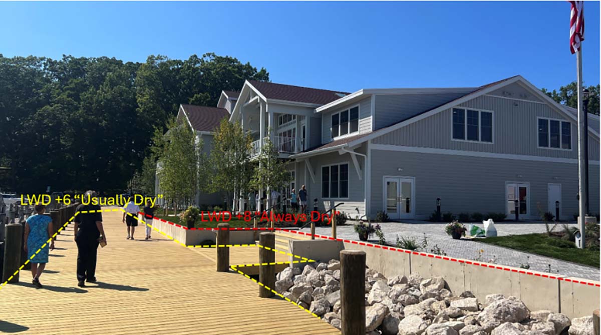
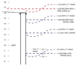
Figure 1 shows the historic high and low static water levels, plus wind setup of 17 inches, plus a 12-inch wave on top of that for a Lake Michigan facility with fixed docks. This results in an absolute “must stay dry” elevation of LWD +8 or higher. The red lines represent a confluence of worst-case conditions that will occur very rarely (possibly two to four times in the 50-year design life) and for a short period of time (usually less than 24 hours).
LWD +6 is a reasonable compromise to keep things dry 98% of the time, while not having the docks any higher than absolutely necessary during low water conditions. At the Michigan Maritime Museum in South Haven, Michigan, the dock walking surface is at LWD +6. We added a second low seat wall to landward that provides an additional 2 feet of elevation to make sure everything upland of that point stays dry in all anticipated conditions.
South Padre Island Marine Park
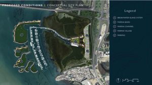
This proposed project, located on the Laguna Madre in South Padre Island, Texas, is essentially at sea level. This facility will utilize a mix of fixed structures closer to shore for the marina village and connecting boardwalk out to the floating docks to the west. The upland marina village area will be at elevation +9 to comply with base flood elevation requirements, while the connecting boardwalk will be at elevation +6 to comply with all electrical datum plane requirements. The floating docks will rise and fall with the tides, and all electrical infrastructure that must stay dry will either be in the village or on the floating docks to prevent damage during hurricane storm surge conditions.
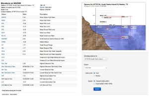
The gangways connecting the fixed pier to the floating docks must accommodate a tidal range of just under 5 feet, with a record low observed tide of -1.9. Assuming a 2-foot freeboard on the floating docks, this means the plan would require a maximum vertical difference of 6.1 feet at low water. This would require a minimum gangway length of 73.2 feet to provide a max slope of 1:12 at low water, so it generally makes sense to specify an 80-foot gangway. At record high tide of elevation 3.9, the surface of the floating dock would be elevation +5.9, so the gangway will slope upwards slightly at record high, but well within the parameters of the gangway design.
In Summary
Planning for water level fluctuations is generally a straightforward exercise when there is good data to work with and an understanding of what can and cannot get wet. In extreme conditions, where locating a building at an elevation that is “always” dry, is not possible, consider designing the building to utilize materials that can withstand short-term flooding and be back in service with a simple cleanup after the floodwaters recede. Designing temporary flood control measures into existing landscape walls, such as slots to accept dashboards similar to what are on boats to keep water out of the cabin, can provide an easy means of keeping water out for short periods that is faster and cheaper than sandbags.
The key is to avoid the temptation to try and outwit Mother Nature and to plan for occasionally wet conditions while maintaining safety and practicality.
| Categories | |
| Tags |