
Knocking on FEMA’s Door — a Practical Guide to Storm Readiness & Resilience
Published on January 18, 2023


An ounce of prevention is worth a pound of cure. That old adage rings crystal clear when it comes to storm mitigation. It is also likely to resonate deep in the core of marina owners and operators — those on the front line of floods, droughts, hurricanes, and storm surges, with the complex and oftentimes devastating consequences that follow.
There is a much better approach than bracing for impact and enduring a costly and all-consuming rebuild in the aftermath of a weather-related event. There is also great wisdom in proactively assessing, documenting, and budgeting for infrastructure that can withstand the highs and lows of our ever-changing climate.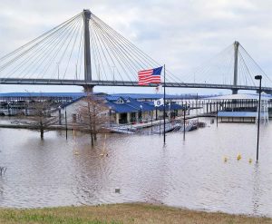
Conduct a Marina Audit
Not knowing the components, condition, location or value of existing marina or waterfront infrastructure can be detrimental to storm readiness. It can also be a nightmare when it comes to trying to secure critical funding for recovery. Conducting a thorough, third-party audit of waterfront property is the foundational first step in determining strengths, weaknesses, and opportunities for improvement.
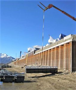
There are a handful of professionals who can conduct an audit of marina assets. However, depending on the complexity of infrastructure in place, a coastal engineer, structural engineer, marina designer (or combination thereof) are likely the best candidates. These individuals can perform a thorough assessment of existing structures, utility networks, drainage, current conditions, and accessibility to ascertain compliance with applicable codes and the safe operation of the facility based on industry best practices. An audit includes an evaluation of all land-based support facilities as well as all inner harbor structures: the condition of piles and piers, the dock system, breakwaters, platforms and gangways, structural connections, seawalls, and more. The resulting report provides a candid and objective review of a marina’s present-state condition and can be immensely helpful in planning and budgeting for improvements or determining if current infrastructure needs upgrading to withstand weather extremes.
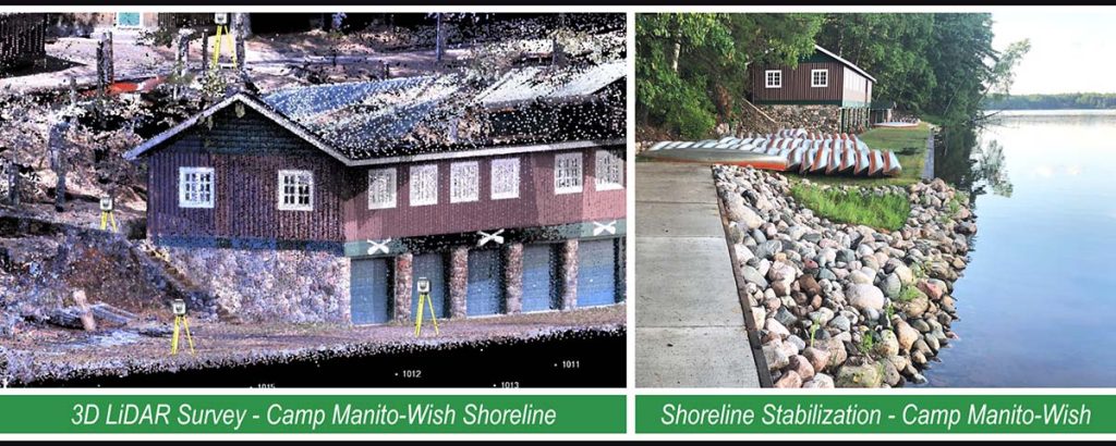
Have the Property Surveyed
A professional land survey is an excellent second step. Here, a surveyor completes a full topographic and boundary survey to determine specific boundary lines and collect data regarding site relief, elevations, shoreline measurements, and flood elevations. Drones can also assist in the process, utilizing technology such as LiDAR (Light Detection and Ranging) 3D scanners to remotely measure land attributes, even though dense vegetation. Data collected via LiDAR can then be used to compile hyper-accurate maps or digital 3D renderings of a property from which a designer can overlay potential project designs or manipulate the model to brainstorm how a marina or waterfront project might look and function within the existing landscape.
Aerial photos are also critical to understanding how things change over time. Whether choosing a traditional ground survey or taking it to the next technological level, a survey is key to documenting site conditions and property ownership rights, which can be instrumental if the landscape is altered by a large storm, wave, wind event, or a natural disaster.
Document Everything
Photos, videos, digital records, maintenance logs, you name it. Document everything. Capturing the existing conditions of all property assets is critical to receiving post-disaster relief funding, particularly from FEMA. Documentation also proves property value and saves critical time in submitting the required paperwork to the agency post-event.
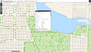
GIS is a game-changer in identifying the geo-specific location and condition of assets, utilities or infrastructure. If disaster does strike, FEMA will want to know the precise mapped locations of these items and the exact extent of damage incurred. How exactly does GIS help? ArcGIS Online is a cloud-based platform by Esri that allows GIS professionals to custom-build applications for any variety of uses. For instance, GIS applications can help streamline the inventory of assets and provide a simple means to share, update and track the condition, maintenance, or replacement of that infrastructure. This is done through something called a “dashboard.” Similar to what you’d find in your vehicle, a dashboard is a visual display of data condensed into easy-to-understand graphic representations. Dashboards are interactive and can track inventory and maintenance in real time, and are accessible to multiple users via any desktop or mobile device. GIS can also help manage natural resources, such as trees, by geo-locating their exact location, documenting each species, tracking tree health, maintenance, and value that increases over time when trees are properly cared for. All of this upfront work yields a noticeable return on investment if — or when — FEMA needs to get involved.
Similar to a digital inventory of assets, digital record-keeping is also key. All critical business files, operational manuals, maps, survey records, plans, and maintenance reports should be duplicated and migrated to online cloud-based platforms, whenever possible. Think about the safest place to otherwise store documents so as not to incur water damage or destruction, such as in a waterproof, fireproof vault, bank, or within a third-party digital storage system. Be meticulous in CYA — Covering Your “Assets.”
Analyze Investments Now
Information gained from a marina audit, survey, and inventory can lead to the development of a marina master plan or a long-range planning document that gives step-by-step structure to budgeting for and implementing any number of desired projects.
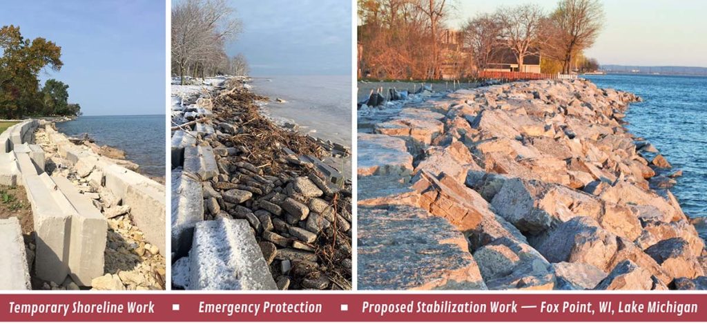
There can be value in making proactive investments in a marina’s infrastructure before it is necessary — particularly for facilities located in flood- or storm-prone areas. The rising number of extreme weather events, paired with an equal rise in the cost of materials, labor and construction, makes it foolhardy to assume that a post-event recovery phase will be swift, or even fully funded. Getting projects done ahead of the curve can save money and ensure a marina remains operational even in the aftermath of a natural disaster.
Design parameters for projects are changing, too, and today’s marina designers are shifting their approach to accommodate more extreme thresholds — both high and low — of waterfront environments. Structures that were once static are now being engineered to float or be high-water resilient. Anchoring systems need to accommodate intensive loadings that come with flood or large surge events. Systems with pile anchoring need to have capacity for longer heights and higher loadings. Cable and winch systems must do the same. Docks with underwater trusses must adapt to accept both high water and unusual water level drawdowns, to name a few.
Marinas taking a scientific, data-driven approach to design or reconstruction projects will likely fare best and will be better positioned to withstand any extreme weather events. Marinas should be evaluated at least every five to 10 years to ensure infrastructure is meeting the latest requirements and best practices.
Be Ready, Be Resilient
Marina audits, surveys, documentation practices, and proactive investments can result in a marked improvement in the resiliency of a marina or waterfront operation and can ease the stress levels of marina management who carry the bulk of the responsibility. While no facility is 100% infallible, making proactive investments and working with a team of professionals can assure boating communities don’t simply endure, but thrive for generations.
Dan Williams, PLA, ASLA, AHLP is senior landscape architect at MSA. He can be contacted at dwilliams@msa-ps.com.

| Categories | |
| Tags |