
Lessons in Sea-Level Change Impacts from the Great Lakes
Published on June 24, 2021


The Great Lakes encompass the largest amount of freshwater in the world in an area covering over 94,000 square miles – earning the region the nickname “the Fresh Coast.” What is less commonly known is those same lakes represent almost half of the total coastline of the contiguous U.S. The five Great Lakes states have a combined 4,530 miles of U.S. coastline, compared to 2,165 miles of Atlantic coast, 1,293 miles of Pacific West Coast, and 1,631 miles along the Gulf of Mexico.
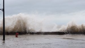
Over the past two years, Fresh Coast communities have been struggling with impacts from record-high water levels that many people do not associate with freshwater lakes. The size and depth of the Great Lakes allow for the generation of storm waves up to 29-feet high, a size rivaling those in the Caribbean Sea and other oceans. The shores of the lakes include the sandy beaches typical of many saltwater coasts, and are exposed to similar coastal processes, including sediment transport, rip currents, storm surge, erosion, and flooding.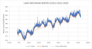
Lake water levels also change at various scales of time, including a semidiurnal (twice-a-day) tide. While a Great Lakes tide is only about two-inches, wind and atmospheric pressure can cause a water-level change of several feet known as seiche: an oscillation wave with a duration of several hours that is often confused with a tide. There are also epochal changes in lake levels associated with larger climatic patterns such as La Niña/El Niño, Polar vortices, and other climate phenomena, producing variations in water levels that can last several months.
When you add unprecedented high-water levels and the increasing impacts of climate change to this dynamic mix of conditions, it presents a whole new set of issues and challenges. Great Lakes water levels can be more variable and trickier than sea levels, since they fluctuate over long-term, seasonal and short-term scales of time. Changes in regional precipitation patterns, freezing and thawing, evaporation, seiche, and storm surges can also have a more immediate impact on water levels in the interconnected lakes.
SmithGroup has spent many years researching and learning how these shifting water levels affect the design and performance of coastal features and structures, ranging from beaches and waterfront promenades to breakwaters and recreational marinas. While some of these dynamics are unique to the Great Lakes, the Fresh Coast still has valuable lessons to offer saltwater coasts in adapting to sea-level change. What can the recent long-term, record-high water levels on the Great Lakes tell us about the potential future effects and impacts of sea-level rise?
Understanding the Problems
Official water level records have been kept for the Great Lakes since 1860, recording the monthly mean. In 1970, the recording of hourly levels started, and in 1996 6-minute mean measurements were added. During 2019 and 2020, all five lakes set their record highs – which was even more remarkable given their quick rebound from near historic lows in 2012. From 2013 to 2020, Lake Michigan/Huron’s mean water level rose a staggering 4.5 feet – a dramatic increase in the historic 13-year cycle between recorded highs and lows.
This rise in water levels can be compared to the expected sea-level-rise scenarios from the International Panel for Climate Change (IPCC); levels of 1.5 to 6 feet are expected by the year 2100. Sea level measurements thus far have confirmed the trend in levels rising due to thermal expansion caused by higher water temperatures and the melting of glaciers and ice caps. A comparable preview of the future global effects of rising sea levels can be seen with the recent rise in the Great Lakes, where thousands of miles of shorelines were subjected to the new stresses of higher water levels.
One key characteristic of these recent record high water levels is that they represent monthly mean conditions and have tended to remain high for several months at a time. This longer duration effectively establishes a new elevated water level state that requires all waterfront areas and infrastructure to adapt to this new condition. Storms occur on top of this higher mean water level, causing additional water level surges and more damaging waves. The deeper nearshore water conditions also allow for larger waves to reach the coast during a storm. Less space for waves to break and dissipate energy increases their capacity for flooding and coastal erosion, leaving the waterfront even more susceptible to damage.
But storms aren’t the only issue to contend with. Waves break when they reach a water depth of approximately 40 to 60 percent of their height. Once waves break they lose energy. Higher water levels allow larger waves to continually reach the shoreline and to impact coastal infrastructure. Shoals, reefs, and natural seabeds lose their ability to start the wave breaking process.

If there is a reduction in waves breaking offshore, they reach the shoreline with more energy. Runup of the waves along the foreshore is increased and the water reaches areas previously not exposed to constant wave breaking. Typically these are areas with finer sands transported by wind, which are more easily transported away by currents; this creates scarfs in the beach and a retreat of sand. Eventually this steeper beach slope becomes unstable and collapses into the water.
These larger nearshore waves also cause an increase in littoral (along-the–shore) sediment transport. The combination of all these effects have led to dramatic coastal erosion in the Great Lakes – a problem that will also increase on saltwater coasts experiencing sea-level change. This is a significant issue since it makes natural or living shorelines increasingly vulnerable to daily erosive forces over time.
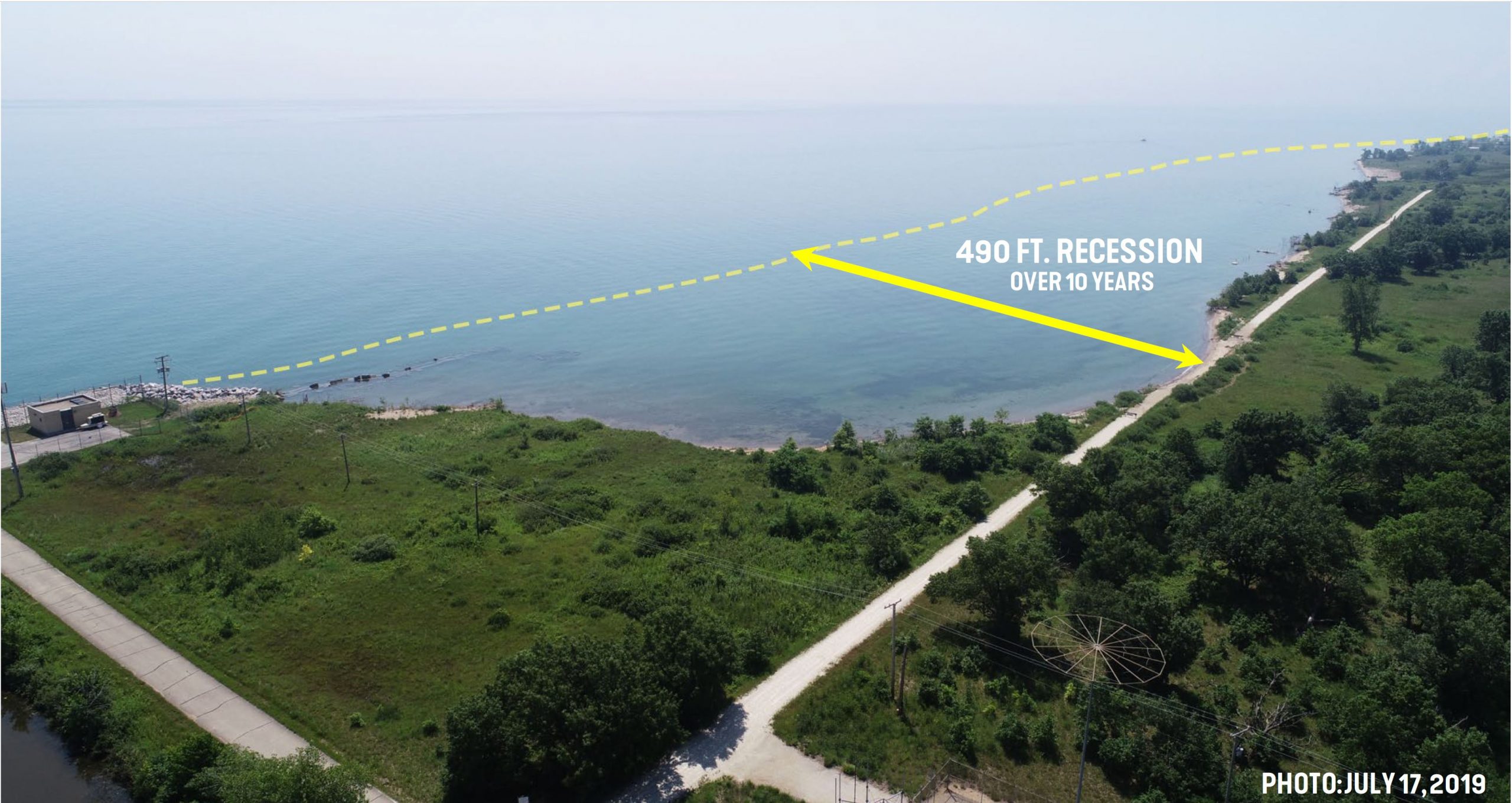
Many destination natural areas that attract recreational boaters and visitors will be highly affected by sea level rise. SmithGroup recently developed a mitigation plan to protect Illinois Beach State Park from severe coastal erosion. The accelerated erosion threatens the park’s rare panne wetlands and its dedicated nature preserves that serve as habitat for threatened or endangered species. This expanse of shoreline also represents the only remaining reach of natural, undeveloped Lake Michigan waterfront in the state of Illinois. Some areas in the park have retreated as much as 490 feet within the last 10 years. The protective measures modeled and recommended for this stretch of shoreline will create and enhance coastal habitats to assure the natural processes remain.
Many other ecologically fragile areas around the world could suffer from erosion and destruction as sea levels increase. Sea turtles could lose most of their nesting grounds globally, and many bird sanctuaries will also be threatened. Preserving and protecting these habitats will require adaptation strategies that account not just for extreme events but for major shifts in daily coastal conditions.
Accounting for Future Conditions
When designing waterfront structures, engineers use extreme probability distributions based on historical data, and design that structure to withstand a statistically more probable extreme storm event. Storms that represent the 100-year return period are commonly used to set the design performance parameters for coastal infrastructure. The storm characteristics are divided into wave heights, wind speeds and water levels – all of which could hypothetically be at 100-year highs during that storm event.
However, it is not common practice to assume that the 100-year storm will occur during the 100-year record high water level – or that storms of lesser severity will occur during that 100-year high-water level. For example, historically a combination of a 10-year return period water level and 20-year storm has been used by Great Lakes engineers. That combination of assumptions proved to be perilous over the past two years along the Great Lakes. Since water levels remained high over a longer period, the chance of encountering a 10-year or more return period storm in conjunction with a 100-year water level was also high. As a result, any minor storm that occurred during these high-water periods created havoc along the waterfront in ways the standard models did not account for – and communities and property owners weren’t prepared for.
How we account for all the factors that can interact during a storm event needs to be revisited – and not only for the Great Lakes. SmithGroup is currently reanalyzing the historical water level information for the Great Lakes to help establish more precise assumptions about potential design conditions. The analysis draws on all the water level data at different scales of time from regional water level gauges. But it is also expanded to include recent years to be sure we establish a level of probability between high water levels and storm conditions that provides a solid and resilient engineering base moving forward.
Costs vs. Paying the Price
High water levels in 2020 caused considerable damage to many Great Lakes communities, including coastal erosion, flooding and damage to paths, beaches, and waterfront structures. The total cost has been estimated at over $500 million, and there is a pressing need to repair and reinforce many outdated structures that are highly susceptible to future damage. Because construction of new protection structures, breakwaters, revetment, and seawalls is occurring at a very high rate, the demand for large armor stone has caused its cost to skyrocket and strained supplies.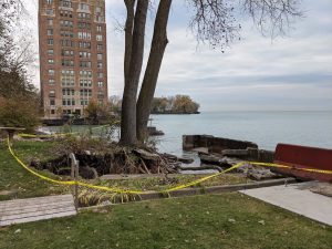
An example of the unanticipated damage that higher water levels can cause occurred in January of 2020 in the Lake Michigan city of Racine, Wisconsin. The combination of high-water levels, lack of ice cover, and a winter storm severely damaged a stretch of over 5 miles of coastline; waves easily overtopped the protective breakwaters, causing severe erosion around the city’s waterfront paths. The beaches lost three quarters of their normal width, leaving the shoreline behind them unprotected. SmithGroup is working with the City to stabilize and ecologically improve the shoreline with more resilient coastal infrastructure that will better protect their beaches and recreational paths.
After the City of Chicago declared a state of emergency following a similarly damaging winter storm, SmithGroup was hired to help them assess conditions and coastal protection needs along their entire 23-mile Lake Michigan shoreline. The process used a risk/vulnerability model to establish four levels of priorities for 63 segments of shoreline.
One important lesson learned is that no matter how urgent the need, it still takes time politically and monetarily to effectively address coastal resilience and start implementing needed enhancements. Construction also takes time, especially under difficult conditions. There is no financially feasible way to protect everything and everyone at once. Given the advance warning that saltwater coasts have with sea-level rise, it is imperative for communities and property owners to get their planning process started as soon as possible.
The recently observed dynamics and damage along the coasts of the Great Lakes provide relevant and useful examples of what many saltwater coasts can expect in the not-too-distant future. In addition to extreme storm and tidal flooding, there will be significant coastal erosion and a higher susceptibility to damage from even mild storms. Increased sediment displacement and movement along shores will also change dredging needs for ports and harbors, as more historically predictable processes of sediment movement begin to change.
There is a need and opportunity to prepare for what lies ahead with sea level rise. Infrastructure needs to be reassessed to determine to what extent it can withstand potential future conditions. Marinas and waterfront communities need to evaluate and manage the physical and economic risks posed by rising water levels. Beaches and natural areas need to be reevaluated to understand and mitigate their potential vulnerabilities.
While sea levels are not predicted to rise as rapidly as the Great Lakes did, some coastal areas are more susceptible than others, especially those that are already affected by land subsidence and/or in the pathway of more potentially damaging storm events. Now is a great time to plan ahead and understand the vulnerability that changing water levels will pose to these coastal areas and facilities. What has recently been observed and experienced on the Fresh Coast is steadily approaching many other coastlines.
Mauricio Wesson is a senior coastal engineer for SmithGroup. He can be contacted at mauricio.wesson@smithgroup.com.

| Categories | |
| Tags |