
The Value of Vision
Published on February 27, 2024


Can you place a value on the vision for your next marina project?
It likely exceeds a simple return on investment — and encompasses more than just the satisfaction of seeing a dream come to fruition. The true value of a vision is much more holistic and includes elements such as time, resources, functionality, quality, minimal maintenance, bills paid, and customers returning. Sustained success. How you achieve that higher echelon of benefits can be a matter of planning — or a matter of luck.
Fortunately, there are technologies that minimize the need to gamble. Marina designers and site developers utilize design tools — 3D modeling and rendering programs such as SketchUp and Lumion — to not only create the artistic side of a vision, but the functional side as well. This software can be applied to projects of all sizes and can be as fundamental or as sophisticated as you choose, with price points to match. The investment is most always worth it, however, particularly for projects of greater scope, complexity, or marketability. Digital design work can yield incredible (and incredibly important) results. It can serve as a marketing tool to draw the attention of future patrons and generate excitement with existing marina visitors. It can also seal the deal on acquiring project investors and funding. Having proof of concept and a detailed project plan for construction shows that you are not only shovel-ready, but shovel-worthy — and that is precisely what private donors, grant, and funding agencies are looking for.
3D Models for Marina Aesthetics
Digital design tools help marina owners realistically mockup and fine tune their visions, assessing which site layout optimizes performance and workflow; where boat slips should be placed to maximize available real estate; how parking and boat launch facilities should be oriented to ensure safe and efficient use; which building materials and color palettes create the right ambiance; and what finishing touches bring that “special something” to the property in the form of landscaping, trails, green spaces, recreation areas, unique amenities, etc.
This is where a professional designer comes into play. Beginning with simple ground or drone photographs, a designer can build a 3D model within the actual digital dimensions and topography of the site. He or she can add virtual light sources within the rendering to mimic the location and angle of the sun at different times of day — or to visualize the scene at nighttime. Programs like Lumion or Enscape allow the designer and the client to play around with different layouts, colors, textures, vegetation, materials, and accessories. The process is efficient. It allows time and space for input from multiple stakeholders, and modifications or new ideas altogether — all well ahead of construction, which saves marina owners time and money.
3D Models for Marina Functionality
Models also streamline the way waterfront facilities function and can identify potential design conflicts early in the process. Facilities such as administrative buildings, ship’s stores, restaurants, dry stack storages, and other marina support buildings can be modeled to enhance the detailing and functionality of the space.
A designer can refine project inputs and parameters within the software to adjust structural design details such as wall or floor thickness, the proposed location of utilities, and building mechanicals. Professionals might utilize other tools as well: augmented reality (AR) applications in which 3D models transform into simulations to demonstrate how building systems will function in real life. Or “digital twins” which are identical digital representations of real-world infrastructure used to model, simulate, and test various building elements and their performance. These digital design elements can be refined until they reach the desired level of development. In fact, very sophisticated models contain all the design information needed to qualify as a contractual deliverable for construction.
3D modeling can be especially advantageous in showing marina conditions and functionality in different seasons or during extreme weather events. Sites with fluctuating water levels, such as marinas along rivers, often experience extreme changes in water height throughout the seasons. Because of this, marina infrastructure must be flexible, mobile, and accessible during both high and low-water events. With 3D models, designers can virtually adjust water levels within a simulated environment and can develop designs that respond to the data gathered — such as choosing the proper floating dock location, height of piers, gangway lengths, connection points to the land, and more.
Manufacturers of marina infrastructure use 3D imagery as well to help them conceptualize how things like underwater chain-and-anchor or cable-and-winch systems, elastic mooring units, or other anchorage installations will function within a particular environment. Being able to understand how these systems work ahead of time saves on costly malfunctions and rework.
3D modeling can also help owners envision future expansion or renovation work. For instance, various components of the marina landscape can be virtually moved around to reveal how future phases of development will look, feel, and function. Owners can visualize ideas like the doubling of available slips, the addition of a building or floating dock system, and more — or the development of an entirely new marina altogether. The possibilities are endless.
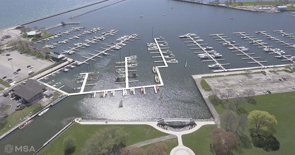
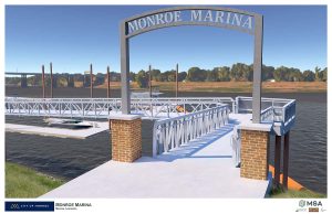
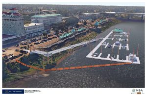
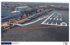
Case Study: Monroe, Louisiana
MSA waterfront designers are working with the city of Monroe on the planning and engineering of a new recreational marina on the Ouachita River, with the goal of boosting traffic in the city’s downtown waterfront and spurring economic development. The marina will integrate into Monroe’s Downtown RiverMarket area, and will provide docking, utility connections, restroom/shower facilities, downtown connectors, and new boater amenities.
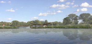
Site challenges for this project include the wildly fluctuating nature of the Ouachita River and its water height variances of up to 30 feet. To aid in design, MSA utilized Lumion, a 3D rendering software, to envision proposed marina infrastructure and its performance at varying water levels. Building upon Google Earth imagery, the team designed a floating dock system, floating building, gangways, and piers that will safely adjust from low-water conditions up to 30 vertical feet — to record-level flood elevation. The five-gangway system is fully inclusive at low water while providing access up to major flood levels, which is the maximum state at which boating is permissible on the river.
The model for the Monroe marina also helped the client understand the tall heights of the piles built into the design. While the piles may look significant at low-water levels, they are foundational to successful anchorage during flood events. Utilizing models, a waterfront designer can test-run different scenarios for things like pile sizing and spacing to determine a preference in appearance (smaller-diameter, frequently spaced piles, or larger piles with a more spacious arrangement) as well as a realistic cost estimate for the most appropriate solution.
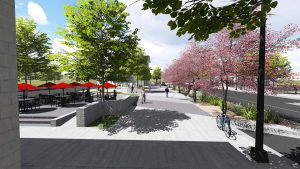
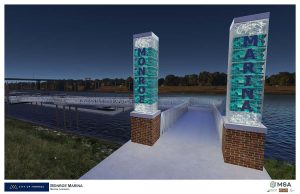
3D modeling has also been used on this project to create aesthetic designs. The city of Monroe envisions the new marina as a gateway to the downtown area, with hopes of encouraging additional boat traffic to visit the community. MSA was able to render concepts for gateway entrances, landscaping, colors, and lighting — including demonstrating how gabion basket-style columns filled with colored lights glow at night and attract attention to the new facility. But just as important, MSA was able to share the vision with the Army Corps of Engineers and Louisiana Levee District as support materials for the permitting of the marina.
The Real Return on Investment
In today’s technological world, marina owners and operators should at least be curious about the suite of digital design and modeling tools at their disposal. Whether used for the ‘soft’ side of a vision or more pragmatic applications, 3D modeling and rendering programs shed light on the design process in an entirely new way. These tools can usher projects through from concept to funding, permit acquisition and construction in an efficient, effective, and affordable manner. And can serve as a catalyst for innovation — a true differentiator in this highly competitive market.
Dan Williams, PLA, ASLA, AHLP, is senior landscape designer at MSA. He can be reached at dwilliams@msa-ps.com. Marcus Rue, PE, is project manager at MSA. He can be reached at mrue@msa-ps.com.
| Categories | |
| Tags |