

Waterfronts Under Pressure: Engineering Solutions for Climate Resilience
Published on January 22, 2026


Designing marinas and waterfront facilities has never been more complex. Rising water levels, stronger storms and unpredictable weather patterns are reshaping the very environments these structures depend on. Engineers and planners now face the challenge of creating infrastructure that not only meets today’s demands but can also withstand tomorrow’s uncertainties. Building climate-resilient waterfronts isn’t just about durability. It’s about innovation, adaptability and safeguarding the communities and economies that thrive along the shores.
Changing Dynamics of the Great Lakes
The Great Lakes region is one striking example of today’s challenges in marina design. Historically considered calmer than marine environments, these vast freshwater bodies are now experiencing conditions once thought exclusive to oceans. Intensifying storms fueled by a steadily warming atmosphere are generating hurricane-force winds and driving waves that rival those of coastal seas. In fact, wave heights on the Great Lakes can regularly reach 20 feet or more during severe weather, creating destructive forces that threaten marinas, breakwaters and shoreline communities. These escalating conditions demand engineering solutions that go beyond traditional freshwater design standards, incorporating robust materials and adaptive strategies to withstand extreme events.
One of the most striking phenomena underscoring this shift is the seiche, a massive oscillation of water within the lake basin akin to water sloshing in a bathtub. While seiches have long occurred on the Great Lakes, their magnitude and frequency are increasing. Recent events on Lake Erie illustrate the danger. Powerful winds during an early winter storm pushed water eastward, dropping levels on the western side of the lake near Toledo almost 10 feet over a 16-hour period to a record low of 561.63 feet. On the eastern shore near Buffalo, the lake experienced a 6-foot rise. This, paired with immense waves, resulted in a nearly 16-foot elevation difference across the lake, conditions that mimic the surge dynamics of hurricanes.
Oscillations such as this can persist for hours or even days, causing flooding, erosion and damage to docks and vessels on one side of the water body, while leaving the other side high and dry, with moored vessels sitting on the lakebed, docks unusable and slippery and unstable ground conditions.
As climate patterns continue to evolve, the Great Lakes are behaving more like inland seas than placid lakes. Reduced ice cover, rising surface temperatures and stronger wind fetch amplify wave energy and storm impacts, eroding shorelines and stressing infrastructure built for milder conditions. For engineers and planners, this means adopting ocean-grade design principles, such as reinforced shorelines and structures, flexible mooring systems and elevated facilities to ensure resilience. The challenge is clear: future waterfronts must be engineered not just for today’s storms, but for a new era of inland waters that increasingly mirror the power of the open ocean.
Case Study: Fox Point, Wisconsin
The village of Fox Point and a scenic 2-mile stretch of residential roadway called Beach Drive is located on the western shore of Lake Michigan. In some locations, only 30 feet separate the road from the lake, creating a picturesque yet precarious environment. In 2019, Lake Michigan’s water level rose by 18 inches to reach near-record heights. Powerful autumnal storms with sustained easterly winds further amplified the conditions, driving powerful waves 6 to 10 feet in height into the shoreline at an alarming rate. Within a mere six weeks, the village documented a loss of up to 7 feet of shoreline along Beach Drive, accompanied by severe erosion, extensive debris and an imminent threat to sanitary sewer mains, stormwater systems and lift station infrastructure running parallel to the shore.

Recognizing the need for a long-term solution, the village applied for and was awarded a National Coastal Resilience Fund grant from FEMA in early 2020. This funding enabled the village to design and construct a robust coastal protection system that would safeguard infrastructure, preserve public access and restore the natural shoreline.
Using the U.S. Army Corps of Engineers’ Coastal Engineering Manual as a foundation, the team hired for the project — MSA and FreshWater Engineering — first conducted a wave climate analysis and numerical modeling to evaluate shoreline protection strategies before determining the most resilient, long-term solution. This solution entailed a robust revetment design, incorporating 3- to 5-ton stones placed at a 3:1 slope beginning at the high-water mark to dissipate wave energy and act as an armor for the shoreline. In total, more than 35,000 tons of revetment stone (more than 1,500 truckloads) was placed along 2,500 feet of the shoreline. Additional improvements included drainage enhancements to manage stormwater and reduce washouts, vegetative stabilization to restore natural buffers and new accessible access points for residents and guests of Fox Point to connect with the waters of Lake Michigan. These measures not only repaired storm damage but also created an aesthetically pleasing shoreline capable of withstanding future high-water events and extreme weather.
Challenges along Inland Lakes and Riverfronts
While the Great Lakes present dramatic examples of climate-driven change, inland lakes and rivers are far from immune. These smaller bodies of water are experiencing their own set of challenges, including more frequent flooding, prolonged droughts and rapid fluctuations in water levels. Increased precipitation can overwhelm river systems, causing erosion and destabilizing banks, while extended dry periods can leave docks and boat launches stranded far from the waterline. For property owners and developers, these extremes complicate everything from shoreline stabilization to the placement of utilities and access points. Designs that once relied on predictable seasonal patterns must now account for a much wider range of conditions.
Case Study: Monroe Transient Marina, Monroe, Louisiana
MSA worked with the city of Monroe, Louisiana, planning and designing a new recreational marina on the Ouachita River, with the goal of boosting traffic and spurring economic development along the community’s waterfront.
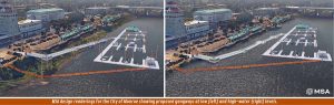
Site challenges for this project include the wildly fluctuating nature of the Ouachita River and its water height variances of up to 30 feet. MSA utilized Lumion, a 3D rendering software, to envision proposed marina infrastructure and its performance at varying water levels.
Building upon Google Earth imagery, the team designed a floating dock system, floating building, gangways and piers that will safely adjust from low-water conditions up to 30 vertical feet to record-level flood elevation. The five-gangway system is fully inclusive at low water while providing access up to major flood levels, which is the maximum state at which boating is permissible on the river.
The model for the Monroe marina also helped the client understand the tall heights of the piles built into the design. While the piles may look significant at low-water levels, they are foundational to successful anchorage during flood events. Utilizing models, a waterfront designer can test run different scenarios for pile sizing and spacing to determine a preference in appearance (smaller-diameter, frequently spaced piles, or larger piles with a more spacious arrangement) as well as determine a realistic cost estimate for the most appropriate solution.
Waterfront and Marina Preparedness
The most effective way to prepare for these uncertainties, no matter the size or location of the waterfront property, is through a comprehensive site assessment conducted by an experienced marina designer or engineer. This study should evaluate hydrology, soil stability, floodplain dynamics and historical water-level trends, along with projected changes in precipitation, temperature and ice activity. Key components include bathymetric mapping of underwater terrain, analysis of wave and fetch direction, wave periods and littoral drift. Understanding these factors helps determine appropriate shoreline protection, structural materials and anchoring systems.
Insights from these assessments inform critical design strategies for adaptability. Structures may need to float or be engineered for flood resilience, with anchoring systems capable of handling higher loads during extreme events. Pile lengths should accommodate worst-case flood conditions and protect against extreme erosion, while docks and trusses must adapt to both high water and unusual drawdowns. Fuel storage tanks and utility connections should be waterproofed or elevated to minimize risk. In regions prone to drought, designers must anticipate extremely low water levels, requiring taller, deeper and more substantial structures. Ultimately, resilience means embracing flexibility — modular components, durable materials and access routes that remain functional during floods.
In Summary
As waterfronts face the realities of a changing climate, resilience is no longer optional; it’s imperative. From the Great Lakes to inland rivers and lakes, the forces reshaping shorelines demand bold, forward-thinking design that blends engineering rigor with adaptability. Every revetment, dock and marina must serve as more than infrastructure; it must be a safeguard for communities, economies and ecosystems that depend on these waters. By embracing innovation and planning for extremes, today’s vulnerabilities can be transformed into tomorrow’s strengths, ensuring that waterfronts remain vibrant, functional and secure for generations to come.
Dan Williams, PLA, ASLA, AHLP, is principal landscape architect at MSA. He can be reached at dwilliams@msa-ps.com. Marcus Rue, PE, is engineering team leader at MSA. He can be reached at mrue@msa-ps.com.
| Categories | |
| Tags |